 |
| From tuvalu2009 |
Now I'm in Tuvalu with a student of Hidenori Watanave laboratory @ Tokyo Metropolitan University and NPO Tuvalu Overview.
We are correcting a lot of pictures, and we will make thousands of placemarks and photo-overlays of Tuvalu on Google Earth, and 3D photograph-oriented space in Second Life, and supporting+communication system of the activity of Tuvalu Overview. Tempolary situation of material collection is as follows.
|
| From tuvalu2009 |
 |
| From tuvalu2009 |
 |
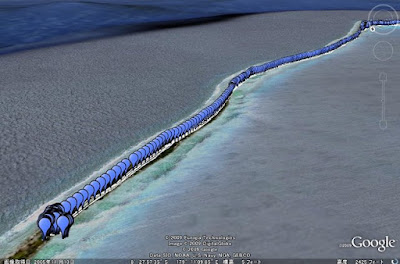
| From tuvalu2009 |
And I uploaded test version of panoramic picture of Tuvalu. This place is the narrowest point in Tuvalu. A violent open sea faces a quiet lagoon. This is a scene that symbolizes Tuvalu on the borderline between development and native exist.
You can scroll it.
It will be open to public in September 2009.
No comments:
Post a Comment